
Monroe ZIP Code Coverage
Monroe County's official GIS boundary legend is reported as displaying 67 ZIP values. Its inspected source table enumerated the 66 labels reproduced below, spanning rural and edge areas, the Rochester 146xx labels, and several Rochester special-use or PO-box values. They are county map labels, not a promise that every address in a polygon receives mail from the named place. Retain the ZIP alongside the municipality and parcel identifier, then verify the delivery address through USPS ZIP Lookup.
| ZIP code | Area covered | Post-office label | Verification note |
|---|---|---|---|
| 14410 | Adams Basin | Adams Basin | PO-box-focused after the 2008 change; verify. |
| 14414 | Avon area | Avon | Check the delivery address and municipality. |
| 14416 | Bergen area | Bergen | Check the delivery address. |
| 14420 | Brockport | Brockport | Verify postal locality. |
| 14423 | Caledonia area | Caledonia | County-edge label; check county and postal boundary. |
| 14428 | Churchville | Churchville | Verify postal locality. |
| 14430 | Clarkson area | Clarkson | May be rural or PO-box delivery; verify. |
| 14445 | East Rochester | East Rochester | Municipality and ZIP overlap can differ. |
| 14450 | Fairport | Fairport | Verify the exact address. |
| 14464 | Hamlin | Hamlin | Verify the exact address. |
| 14467 | Henrietta | Henrietta | Town and post-office association can differ. |
| 14468 | Hilton | Hilton | Verify the exact address. |
| 14470 | Holley area | Holley | County-edge association; verify. |
| 14472 | Honeoye Falls | Honeoye Falls | Verify the exact address. |
| 14475 | Ionia area | Ionia | Exact delivery status was not individually confirmed. |
| 14476 | Kendall | Kendall | Verify the exact address. |
| 14482 | Le Roy edge | Le Roy | Check the municipal and county side. |
| 14502 | Macedon edge | Macedon | County GIS value; verify. |
| 14506 | Mendon | Mendon | Verify the exact address. |
| 14511 | Mumford | Mumford | Verify the exact address. |
| 14514 | North Chili | North Chili | Verify the exact address. |
| 14515 | North Greece | North Greece | Verify the exact address. |
| 14519 | Ontario edge | Ontario | County GIS value; verify. |
| 14526 | Penfield | Penfield | Verify the exact address. |
| 14534 | Pittsford | Pittsford | Verify the exact address. |
| 14543 | Rush | Rush | Verify the exact address. |
| 14546 | Scottsville | Scottsville | Verify the exact address. |
| 14559 | Spencerport | Spencerport | Receives the 2008 Adams Basin realigned deliveries. |
| 14564 | Victor edge | Victor | Check the county boundary. |
| 14580 | Webster | Webster | Verify the exact address. |
| 14586 | West Henrietta | West Henrietta | Verify the exact address. |
| 14602 | Rochester special downtown area | Rochester | Address-level USPS confirmation is required. |
| 14604 | Rochester downtown | Rochester | A postal label, not a municipal boundary. |
| 14605 | Rochester | Rochester | Verify the exact address. |
| 14606 | Rochester west area | Rochester | Verify the exact address. |
| 14607 | Rochester East Avenue area | Rochester | Verify the exact address. |
| 14608 | Rochester southwest area | Rochester | Verify the exact address. |
| 14609 | Rochester northeast area | Rochester | Verify the exact address. |
| 14610 | Rochester southeast area | Rochester | Verify the exact address. |
| 14611 | Rochester southwest area | Rochester | Verify the exact address. |
| 14612 | Rochester Charlotte area | Rochester | Verify the exact address. |
| 14613 | Rochester northwest area | Rochester | Verify the exact address. |
| 14614 | Rochester county-seat core | Rochester | Verify the exact address. |
| 14615 | Rochester northwest edge | Rochester | Verify the exact address. |
| 14616 | Greece/Rochester label | Rochester | Town and postal city can differ. |
| 14617 | Irondequoit/Rochester label | Rochester | Town and postal city can differ. |
| 14618 | Brighton/Rochester label | Rochester | Town and postal city can differ. |
| 14619 | Rochester southwest | Rochester | Verify the exact address. |
| 14620 | Rochester south-central | Rochester | Verify the exact address. |
| 14621 | Rochester northeast | Rochester | Neighborhood and ZIP are not municipal boundaries. |
| 14622 | Irondequoit/Rochester label | Rochester | Town and postal city can differ. |
| 14623 | Henrietta/Rochester label | Rochester | Campus, commercial, and town overlap is possible. |
| 14624 | Gates/Rochester label | Rochester | Town and postal city can differ. |
| 14625 | Brighton/Penfield/Rochester label | Rochester | Parcel and delivery boundaries may not match. |
| 14626 | Greece/Rochester label | Rochester | Town and postal city can differ. |
| 14627 | Rochester institution/special use | Rochester | Delivery class or organization was not located in the legend. |
| 14639 | Rochester special use/PO box | Rochester | Exact facility coverage was not individually confirmed. |
| 14642 | Rochester special use/PO box | Rochester | Exact facility coverage was not individually confirmed. |
| 14643 | Rochester special use/PO box | Rochester | Exact facility coverage was not individually confirmed. |
| 14644 | Rochester special use/PO box | Rochester | Exact facility coverage was not individually confirmed. |
| 14646 | Rochester special use/PO box | Rochester | Exact facility coverage was not individually confirmed. |
| 14647 | Rochester special use/PO box | Rochester | Exact facility coverage was not individually confirmed. |
| 14649 | Rochester special use/PO box | Rochester | Exact facility coverage was not individually confirmed. |
| 14650 | Rochester special use/PO box | Rochester | Exact facility coverage was not individually confirmed. |
| 14692 | Rochester special use/PO box | Rochester | Exact facility coverage was not individually confirmed. |
| 14694 | Rochester special use/PO box | Rochester | Exact facility coverage was not individually confirmed. |
Note: Check the live county legend for its reported 67th value; USPS remains the source for the current ZIP assigned to one delivery address.
Monroe ZIP Codes Need USPS Confirmation
A Monroe ZIP code should be checked at the address level before it becomes part of a record search. USPS offers three separate routes: an address-to-ZIP search, a city-and-state search, and a ZIP-to-city search. Its results can use a recognized postal city that differs from the town or village named by county records. The result also does not prove that a named person or organization receives mail there. Keep the postal result as an address-validation note, then use the matching local custodian for the next record.
| USPS lookup field | Observed format or purpose |
|---|---|
| Street Address | Required in address mode. |
| Apt/Suite/Other | Optional refinement for a unit. |
| City and State | Required in address and city/state modes. |
| ZIP Code | Required in ZIP mode and optional as an address refinement. |
| Company | Optional in address mode; it does not confirm a person or entity. |
Use the official USPS tool for that check. When it returns several possible matches, narrow by street number and unit rather than selecting a nearby result. A ZIP code directory can guide the search area, but a validated street address is the stronger key.
Monroe ZIP Code History at Adams Basin
Adams Basin 14410 is a Monroe postal-history trap. A USPS Postal Bulletin records that seven deliveries moved to Spencerport 14559 on June 14, 2008, and that 14410 became PO-box-only five days later. An older directory, tax record, or deed-related mailing address can therefore carry a label that does not match the current delivery ZIP. Preserve the label and date found in the old record before normalizing anything.
This is a useful example of why a ZIP code directory should not collapse postal history into a present-day town name. Near a county edge, the current USPS answer, the historical label, the municipal jurisdiction, and the parcel boundary can all matter. Record all four when comparing a past address with a current one.
Mapping Monroe ZIP Code Boundaries
The Monroe County ZIP boundary legend is visible in the county's boundary service, and the ZIP sublayer can be identified or queried. It is marked not searchable in the Parcel Viewer. That means a researcher should inspect the map or make a spatial query, then join the result to the parcel's situs address and SBL, the county's tax-map identifier. It is not a ZIP text-search directory for names.
The official county legend is shown here as a reference capture. It is best used to compare postal labels with the parcel and municipal layers that surround the address.
View the official Monroe County ZIP layer legend before using the map service.
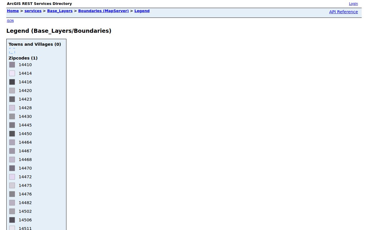
The layer should be checked with the current parcel and USPS results so a map label is not mistaken for a delivery or residence finding.
Finding Monroe Residents by ZIP Code
A Monroe ZIP code directory can narrow an address question, but it should not be used to create a ZIP-wide list of people. The county Real Property Portal is the property entry point for address, owner/business, and SBL work, though the inspected live interface did not expose its detailed control labels. The Parcel Viewer supplies the map relationship. For a known person and address, the Board of Elections tool has a ZIP field as part of its individual verification form, not as a public block roster.
- Confirm the current postal ZIP with USPS and write down the postal city separately from the municipality.
- Inspect the ZIP polygon and the target parcel in the county map, then save the parcel's SBL and map retrieval date.
- Use the property portal or municipal assessment route for the address or SBL, keeping the situs address and mailing address in separate fields.
- When a supplied person needs a current election relationship checked, use Monroe County's voter lookup with its street, ZIP, surname, and date-of-birth fields only as authorized.
New York voter data has its own access rules. A formal file request goes through the records route and must state an elections purpose under Election Law §3-103(5); the state describes a written request or GovQA route, file layout, and applicable copy rules. Confidential voter protections still apply. Once a ZIP has narrowed the area to a named street, use the Monroe street directory for the address-by-address record trail.
Monroe ZIP Code Property Searches
For a Monroe ZIP code question about one property, the postal label is a narrowing tool rather than the final search field. Monroe County Real Property Tax Service maintains assessment rolls and tax maps, while the Real Property Portal is the individual-property entry point for property information, taxes, historical sales, and payment. The documented property workflow uses an address, owner or business name, or SBL. The live portal did not expose its detailed labels during the research inspection, so a search should not assume an unobserved ZIP filter exists.
Move from the validated ZIP to the map, then from the mapped parcel to its address or SBL. The assessment record can distinguish a property owner, a mailing recipient, and the situs address. For the legal transfer record, use Monroe County Clerk land records and the IQS index. Index information remains a discovery layer; document images can require a subscription, a Clerk copy request, a public terminal, or microfilm for older material. A sale or mailing address is not proof of occupancy.
Monroe ZIP Code Research Keys
Postal geography is only one of several Monroe keys. A ZIP can span places commonly associated with Brighton, Greece, Irondequoit, Henrietta, Gates, Penfield, and Rochester. The postal city printed by USPS may not be the town or city that assesses the parcel. For a deed or assessment question, the SBL and municipality are usually more stable than the ZIP; for a community question, a city neighborhood label may add context without changing the legal parcel boundary.
- ZIP versus ZIP+4
- A five-digit ZIP identifies a delivery area. ZIP+4 adds a more specific delivery segment and is not a municipal boundary.
- PO-box ZIP
- A ZIP used for post-office boxes can differ from the code used by a physical street delivery.
- Special-use ZIP
- A county legend label that may serve a specialized Rochester delivery context; the research did not confirm the facility for every such value.
- Carrier route
- A postal delivery grouping. It can help USPS sort mail but does not establish a neighborhood, parcel line, or household.
Monroe ZIP Code Boundaries and City Lines
Rochester 146xx labels are postal labels, not neighborhood or city-limit declarations. The research specifically identifies 14616 with Greece/Rochester, 14617 and 14622 with Irondequoit/Rochester, 14618 with Brighton/Rochester, 14623 with Henrietta/Rochester, 14624 with Gates/Rochester, and 14625 with Brighton, Penfield, and Rochester associations. A parcel can therefore need town records even when its mail says Rochester.
When a government record needs correction or a copy, start with the office that holds it. The Monroe County FOIL page explains the county request route, but FOIL does not require an agency to create a new resident list. Court records follow Judiciary Law §255 procedures rather than county FOIL.
Note: A municipal boundary, postal ZIP, and city-defined neighborhood can overlap, but none should be substituted for another in a Monroe record search.